At the end of September, there were several juvenile purple gallinules at Celery Fields
 | |||
|
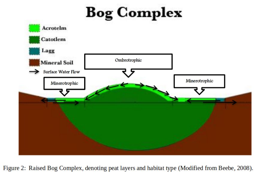
At the end of September, there were several juvenile purple gallinules at Celery Fields We walked the 3 mile red trail at the T. Mabry Carlton, Jr. Memorial Reserve Thanksgiving weekend. It was well marked and mowed, but probably only 20% shaded. No dogs are allowed. The trail was dry, but several spots looked like they would be impassible during the wet season. There were no mosquitoes. We saw 3 hawks and several white peacock and sleepy orange butterflies. There was widespread hog damage, and we heard and then saw two groups of feral hogs with piglets rummaging around. wild bachelor’s button pale meadow beauty pine and palmetto One of the most interesting places that we visited in Maine was the Orono Bog Boardwalk adjacent to Bangor City Forest. Descriptions below are paraphrased from the well-done signs posted along the boardwalk. The boardwalk starts in dense, swampy, and mosquitoey forest. This outer perimeter of the bog is the lagg, where runoff from the raised bog and from the surrounding mineral soils collect and slowly flow around the bog. As the ground rises by a few inches from peat accumulation, the boardwalk crosses the Conifer Wooded Fen. Less water from mineral soil reaches here. The soil at this point is around 16 feet of peat, then 4 feet of lake sediment deposits, and then mineral silt-clay beneath, which prevents drainage. pH 4.4 A rocky ridge brings mineral soil to the surface, allowing for better growing conditions, though the pH is still 4.2. When the bog raises enough to no longer receive water from the surrounding mineral soils, the Wooded Shrub Heath begins. The stunted trees here are the same species as the surrounding area (black spruce and tamarack), and some are as old as 100 years, but they only receive nutrients from the atmosphere. The peat here is around 12 feet deep, resting on mineral silt-clay. pH 3.9 Carniverous pitcher plants (below) are common, which get nutrients from catching insects. Plants in the heath family, such as Labrador tea, sheep laurel and bog rosemary, have fungi on their roots to help them obtain nutrients from the peat. Moss Lawns of Sphagnum moss and tussock cotton-grass form in the hollows where the water level is at or just below the surface. Hummocks, resulting from the upward growth of shrubs and moss, are raised as much as a foot above the lawns. Different species of Sphagnum grow in the hollows than the drier hummocks. The peat is around 16 feet deep with a pH of 3.8. The “boardwalk “floats†atop the water-saturated peat. Footings, consisting either of plastic-wood composite material or dock floats” keep the boardwalk from sinking into the peat. A depth to water gauge during our visit reported the water level at 1″ below the surface, and you could see the standing water when looking down at the footings for the boardwalk. From Ecological Processes in the Bog Walk: What is a Peatland? by Sue Priest
Soil pH affects nutrient availability by changing the form of the nutrient in the soil. Lower pH increases the solubility of Al, Mn, and Fe, which are toxic to plants in excess. Extreme pH values decrease the availability of most nutrients. (source) Peatland Acidification and pH:
The only way to access the island of Vinalhaven is by boat or plane. Maine DOT runs a ferry several times a day between Rockland and the island (1 hour 15 minutes/15 miles), where a village with a large lobster fishing fleet resides. On our way to the ferry terminal, we stopped at the Rockland Breakwater Lighthouse. The weather was worsening, so we didn’t walk all the way out. We found these isopods running in between the breakwater rocks, probably sea slaters. Cormorants When we arrived on Vinalhaven, a generous stranger gave us a short ride to the hotel we were staying at, which sits on a bridge where the tide (which varies by around 10 feet) flows in and out underneath. There was a thick fog that evening where we couldn’t see the yellow house across the harbor from the hotel. Near low tide the next day, we got a ride from the hotel to the Basin. A small network of trails winds through the forest to access points to the protected cove. The northernmost access point was the most interesting. Some small fish were caught in the uppermost pool of water. This crab, though missing several legs, was still alive in one of the tide pools In the last three decades of the 19th century, the island’s primary industry was granite quarrying. Two of the larger quarries on the island are now swimming holes. This spot is just a nursery for mosquitoes, which were numerous enough in the forest to curtail photography. In the afternoon I walked to Lane’s Island Preserve One of the ferries returning to Rockland, with lobster pot floats in the foreground This juvenile herring gull was pestering what I presume was one of its parents. The gulls in Maine are larger than the ones in Florida. White admiral The Ship Harbor trail follows the mudflats of an inlet on one side, takes you to the headland where you can peek in tide pools, and then back through an open, rocky woodland with spruce and larch. Snails were abundant Rose bushes, with large rose hips, were common along the roadside and near the shore The Sieur de Monts Wild Gardens of Acadia has nicely arranged sections representing different habitats around the park, with labels for the plants you might find. There are many kinds of goldenrod. Small fish were in the stream behind the cardinal flowers. Further on the two lane, one-way section of the park loop road, there were signs allowing parking in the right lane. Parked cars stacked up before the signs identified which attraction the cars were parked for. We were lucky and found spots in the main parking lot for the places we stopped at. Sand Beach is appropriately named in a place where all other shoreline we saw was rocky or muddy. It was in the low 70s, and some folks were in bathing suits and playing in the water. Jordan Pond |
|||
 | |||